
Subdivision Information
Utah Code 10-9a-6 enables cities and counties to create the process to divide property within their jurisdictions. Enoch City complies with these standards in 3 separate processes; Preliminary Plat, Final Plat, and Minor Subdivision and provides landowners the information below:
WHAT TO DO:
Submit this completed checklist and all supporting documents to the City Manager, Rob Dotson ([email protected]) or submit online at the link above. Pay the application fee 0 to 10 lots =$350, additional 11-20 lots = +$525, Every Additional 10 lots = $150) on the City website. Before submitting a FINAL plat application, you must have obtained an approval on the related preliminary plat application.
Submit this completed checklist and all supporting documents to the City Manager, Rob Dotson ([email protected]) or submit online at the link above. Pay the application fee 0 to 10 lots =$350, additional 11-20 lots = +$525, Every Additional 10 lots = $150) on the City website. Before submitting a FINAL plat application, you must have obtained an approval on the related preliminary plat application.
WHAT TO EXPECT:
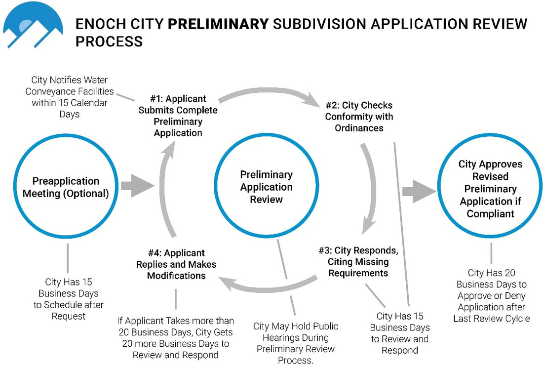
City staff will review your application and determine whether it is complete. It is your responsibility as the applicant to comply with City ordinances. Any application deemed incomplete will be returned to you for necessary corrections and will not be considered filed with the City until you have corrected and resubmitted it.
When your application is complete, the City will review and respond to your application within 15 business days. You may be required to revise your application to conform to City ordinances and standards or to better protect the health and safety of Enoch City residents. If the City approves your preliminary application, you must then submit a final application.
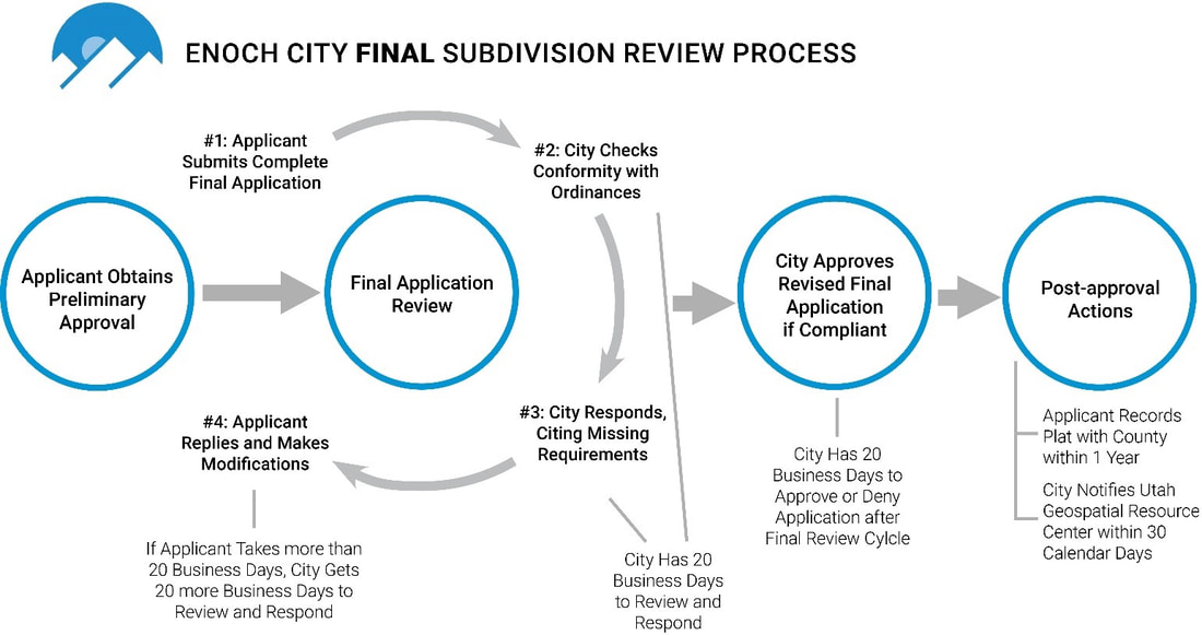
The review and approval process, as well as the application requirements, are governed by City ordinance chapters 12.2400–12.3000.
City staff will review your application and determine whether it is complete. It is your responsibility as the applicant to comply with City ordinances. Any application deemed incomplete will be returned to you for necessary corrections and will not be considered filed with the City until you have corrected and resubmitted it.
When your application is complete, the City will review and respond to your application within 15 business days. You may be required to revise your application to conform to City ordinances and standards or to better protect the health and safety of Enoch City residents. If the City approves your preliminary application, you must then submit a final application.
The review and approval process, as well as the application requirements, are governed by City ordinance chapters 12.2400–12.3000.
Documents Required
|
Preliminary Plat
|
Final Plat
|
|
1 ______ An approved land use application that describes how the property will be used after it is subdivided. This land use application must include an approved conditional use permit, an approved variance, or citations to specific municipal ordinances that permit the intended use.
2 ______A preliminary plat, drawn to scale, in detail, and in accordance with generally accepted surveying standards and the acceptable filing standards of the County Recorder’s Office. The plat must include: a ______The proposed name and general location of the subdivision, in bold letters at the top of the plat. The proposed subdivision name must be distinct from any subdivision name on a plat recorded in the County Recorder's Office. b ______The boundaries, course, numbering, and dimensions of all proposed parcels. All lots should be consecutively numbered. c ______The lot or unit reference; block or building reference; street or site address; street name or coordinate address; acreage or square footage for all parcels, units, or lots; and length and width of the blocks and lots intended for sale. d ______The parcel numbers of all adjoining property owners of record, or the names of adjoining developments and the names of adjoining streets. e ______The address and phone number of the land surveyor and/or engineer who prepared the plat. f ______Sufficient data acceptable to the City Engineer to readily determine the location, bearing and length of all lines on the plat, and to reproduce such lines upon the ground, and the location of all proposed monuments, including contours at appropriate intervals. g ______Whether any parcel is intended to be used as a street or for any other public use. h ______The names, numbers, widths, lengths, bearings, and curve data on centerlines for all proposed streets, alleys, and easements (if applicable). All proposed streets shall be numbered and named in accordance with the City’s adopted addressing system. i ______The location of existing streets, easements, water bodies, streams, and other pertinent features such as wetlands, buildings, parks, cemeteries, drainage ditches, irrigation ditches, fences, and bridges. j ______The location and width of existing and proposed streets, curbs, gutters, sidewalks, easements, alleys, other public ways and easements and proposed street rights-of-way and building setback lines. k ______Every existing right-of-way and recorded easement located within the plat for underground, water, and utility facilities. l ______Any known and unrecorded water conveyance facility located, entirely or partially, within the plat, including sanitary sewers, storm drainage facilities, fire hydrants, and pumping stations. m _____Location and size of all proposed water, secondary water, sanitary sewer, storm sewer, irrigation or drainage ditch piping or other subsurface improvements, including detailed provisions for collecting and discharging surface water drainage. n ______Whether any parcel is reserved or proposed for dedication for a public purpose. o ______The location and dimensions of all property proposed to be set aside for park or playground use, or other public or private reservation, with designation of the purpose thereof and conditions, if any, of the dedication or reservation. 3 ______A stormwater drainage plan provided in accordance with City Engineering Standards and Enoch City storm drain system master plans. 4 ______A water modeling analysis using Enoch City’s Water model covering the primary and secondary water needs and likely impact of the intended subdivision use on the City and surrounding area. 5 ______A wastewater modeling analysis using Enoch City’s Wastewater model covering the wastewater needs and likely impact of the intended subdivision use on the City and surrounding area. 6 ______A soils report from a qualified soils engineer identifying the types of soils within the proposed subdivision area and identifying any soils constraints on the proposed subdivision. 7 ______A traffic study, if one is required by an applicable UDOT Access Management Plan or if the Land Use Authority informs an applicant that one is required. 8 ______An improvement plan, created in accordance with applicable portions of chapters 12.2500 and 12.2700 of the City’s municipal ordinances, for all public improvements proposed by the applicant or required by City ordinances. In addition to the requirements in chapters 12.2500 and 12.2700, the improvement plan must contain an engineer’s estimate of the cost of completing the required improvements. 9 ______Certifications, including: a ______An affidavit from the applicant certifying that the submitted information is true and accurate (EXAMPLE). b ______The signature of each owner of record of land described on the plat, signifying their dedication and approval of the plat (EXAMPLE). c ______Certification that the surveyor who prepared the plat: i ______Holds a license in accordance with Utah Code 58-22; and ii ______Either (1) ______Has completed a survey of the property described on the plat in accordance with state requirements and has verified all measurements; or (2) ______Has referenced a record of survey map of the existing property boundaries shown on the plat and verified the locations of the boundaries; and iii ______Has placed monuments as represented on the plat. 10 ______Three 11”x17” printed copies of the preliminary plat. 11 ______An electronic copy of all plans in PDF format. 12 ______Payment of the subdivision application fee (0 to 10 lots =$350, additional 11-20 lots = +$525, Every Additional 10 lots = +$150) and any other application-processing fees described in the City’s fee schedule. (i.e. Civil Plan Review) |
1______ The City Engineer’s approval of the preliminary subdivision application.
2 ______ An approved land use application that describes how the property will be used after it is subdivided. This land use application must include an approved conditional use permit, an approved variance, or citations to specific municipal ordinances that permit the intended use. 3 ______ A final plat, drawn to scale, in detail, and in accordance with generally accepted surveying standards and the acceptable filing standards of the County Recorder’s Office. The plat must include: a ______ The proposed name and general location of the subdivision, in bold letters at the top of the plat. The proposed subdivision name must be distinct from any subdivision name on a plat recorded in the County Recorder's Office. b ______ The boundaries, course, numbering, and dimensions of all proposed parcels. All lots should be consecutively numbered. c ______ The lot or unit reference; block or building reference; street or site address; street name or coordinate address; acreage or square footage for all parcels, units, or lots; and length and width of the blocks and lots intended for sale. d ______ The parcel numbers of all adjoining property owners of record, or the names of adjoining developments and the names of adjoining streets. e ______ The address and phone number of the land surveyor and/or engineer who prepared the plat. f ______ Sufficient data acceptable to the City Engineer to readily determine the location, bearing and length of all lines on the plat, and to reproduce such lines upon the ground, and the location of all proposed monuments, including contours at appropriate intervals. g ______ Whether any parcel is intended to be used as a street or for any other public use. h ______ The names, numbers, widths, lengths, bearings, and curve data on centerlines for all proposed streets, alleys, and easements (if applicable). All proposed streets shall be numbered and named in accordance with the City’s adopted addressing system. i ______ The location of existing streets, easements, water bodies, streams, and other pertinent features such as wetlands, buildings, parks, cemeteries, drainage ditches, irrigation ditches, fences, and bridges. j ______ The location and width of existing and proposed streets, curbs, gutters, sidewalks, easements, alleys, other public ways and easements and proposed street rights-of-way and building setback lines. k ______ Every existing right-of-way and recorded easement located within the plat for underground, water, and utility facilities. l ______ Any known and unrecorded water conveyance facility located, entirely or partially, within the plat, including sanitary sewers, storm drainage facilities, fire hydrants, and pumping stations. m ______Location and size of all proposed water, secondary water, sanitary sewer, storm sewer, irrigation or drainage ditch piping or other subsurface improvements, including detailed provisions for collecting and discharging surface water drainage. n ______ Whether any parcel is reserved or proposed for dedication for a public purpose. o ______ The location and dimensions of all property proposed to be set aside for park or playground use, or other public or private reservation, with designation of the purpose thereof and conditions, if any, of the dedication or reservation. 4 ______ A stormwater drainage plan provided in accordance with City Engineering Standards and Enoch City storm drain system master plans. 5 ______ A water modeling analysis using Enoch City’s Water model covering the primary and secondary water needs and likely impact of the intended subdivision use on the City and surrounding area. 6 ______ A wastewater modeling analysis using Enoch City’s Wastewater model covering the wastewater needs and likely impact of the intended subdivision use on the City and surrounding area. 7 ______ A soils report from a qualified soils engineer identifying the types of soils within the proposed subdivision area and identifying any soils constraints on the proposed subdivision. 8 ______ A traffic study, if one is required by an applicable UDOT Access Management Plan or if the Land Use Authority informs an applicant that one is required. 9 ______ An improvement plan, created in accordance with applicable portions of chapters 12.2500 and 12.2700 of the City’s municipal ordinances, for all public improvements proposed by the applicant or required by City ordinances. In addition to the requirements in chapters 12.2500 and 12.2700, the improvement plan must contain an engineer’s estimate of the cost of completing the required improvements. 10 ______A completion assurance for public improvements, or a statement that all public improvements will be completed before development occurs on the proposed subdivision and before the applicant records the plat, as required by municipal ordinance 12.2600. 11 ______ Payment of a Water Acquisition Fee or binding documents enacting a Water Right Transfer as described in municipal ordinances 12.2400.2413 and 14.100.113. 12 ______ A Preliminary Title Report or Title Insurance Policy for the land to be subdivided verifying property ownership. 13 ______ As applicable, formal, irrevocable offers for dedication to the public of streets, City uses, utilities, parks, easements, or other spaces. 14 ______ If the plat is to be part of a community association, signed and binding documents conveying to the association all common areas. 15 ______ Certifications, including: a ______ An affidavit from the applicant certifying that the submitted information is true and accurate (EXAMPLE). b ______ The signature of each owner of record of land described on the plat, signifying their dedication and approval of the plat (EXAMPLE). c ______ Certification that the surveyor who prepared the plat: i ______ Holds a license in accordance with Utah Code 58-22; and ii ______ Either (1) ______ Has completed a survey of the property described on the plat in accordance with state requirements and has verified all measurements; or (2) ______ Has referenced a record of survey map of the existing property boundaries shown on the plat and verified the locations of the boundaries; and iii ______ Has placed monuments as represented on the plat. 16 ______ Copies, including: a ______ Two paper copies (24” x 36”) of the final plat; b ______ One electronic copy of the final plat in AutoCAD format (DWG or DXF), Geodatabase format (GDB), or Shapefile format (SHP), with a projection assigned to the file(s) and with the proper metadata that describes what coordinate system/projection the data is assigned to; and c ______ A PDF document of the final plat and all other plans and supporting documents. 17 ______ Payment of the subdivision application fee (0 to 10 lots =$350, additional 11-20 lots = +$525, Every Additional 10 lots = +$150) and any other application-processing fees described in the City’s fee schedule (i.e. Civil Plan Review) |

ENOCH CITY CORPORATION
900 EAST MIDVALLEY ROAD ENOCH, UTAH 84721 |
PHONE: 435-586-1119
FAX: None Office Hours: Monday - Thursday 9 am - 4:30 pm., Friday 9 am - 1 pm |
|